

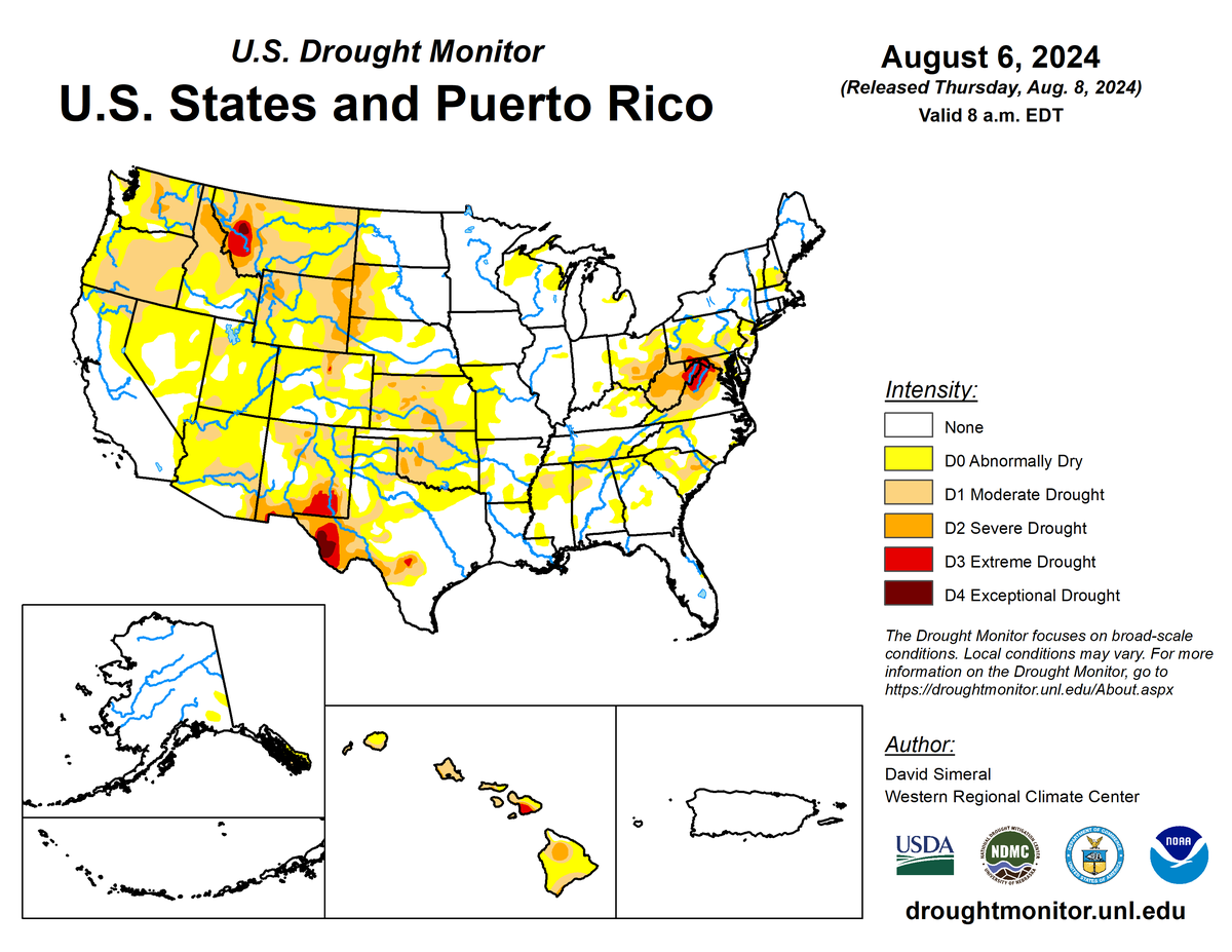
According to the August 6, 2024 U.S. Drought Monitor, moderate to exceptional drought covers 18.2% of the United States including Puerto Rico, an increase from last week’s 16.9%. The worst drought categories (extreme to exceptional drought) stayed about the same as last week’s 1.2%.
High-pressure ridges dominated the upper-level circulation pattern over the contiguous U.S. (CONUS) during this U.S. Drought Monitor (USDM) week (July 31–August 6). They were responsible for the warmer- and drier-than-normal weather that occurred across much of the country. Upper-level troughs of low pressure moved in the jet-stream flow along the Canadian border. They sent cold fronts across the Plains and eastern U.S., but temperatures were not that much different behind them. They mainly served as boundaries that triggered showers and thunderstorms which brought above-normal precipitation to parts of the Midwest and Northeast and a few areas in the Pacific Northwest and northern Plains. Summer monsoon showers and storms dotted the Four Corners states. Near the end of the week, Hurricane Debby dumped considerable rain across the coastal Southeast as she slowly moved inland. Meanwhile, high pressure and dry trade winds kept Hawaii drier than normal; Alaska was mostly cooler than normal with a mixed precipitation anomaly pattern, and Puerto Rico and the U.S. Virgin Islands were generally warmer and wetter than normal.
Drought or abnormal dryness contracted where heavier rain fell across much of the Southeast and into the Ohio Valley, as well as a few parts of the Southwest, Alaska, and Hawaii. But the continued dryness and heat expanded or intensified drought or abnormal dryness across much of the West and Great Plains, as well as parts of the Lower Mississippi Valley and Hawaii.
Nationally, expansion was more than contraction, so the nationwide moderate to exceptional drought area percentage increased this week. Abnormal dryness and drought are currently affecting over 106 million people across the United States including Puerto Rico—about 34.3% of the population.
The full U.S. Drought Monitor weekly update is available from Drought.gov.
In addition to Drought.gov, you can find further information on the current drought as well as on this week’s Drought Monitor update at the National Drought Mitigation Center.
The most recent U.S. Drought Outlook is available from NOAA’s Climate Prediction Center and the U.S. Department of Agriculture provides information about the drought’s influence on crops and livestock.
For additional drought information, follow #DroughtMonitor on Facebook and Twitter.


